- The UAE Border Map: Saudi Arabia, Oman, and the Sea
- Barakah and Al Dhafra: A Target in the UAE’s Far West
- The Yemen Axis: From Houthi Areas to Western UAE
- January 2022: Abu Dhabi Under Missile and Drone Routes
- Yemen’s Al Jawf: A Launch Point Toward the Arabian Peninsula
- The Iraq Axis: A Northwestern Route to the UAE
- The Iran Axis: The Gulf as a Direct Route
- How Did Missiles and Drones Enter UAE Airspace?
- The Western Border: Why It Returned to the Forefront
- Timeline of Attacks and Routes
- Danger Map
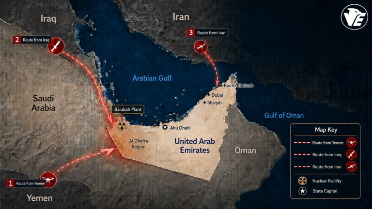
Dubai, United Arab Emirates – The targeting of the area surrounding the Barakah Nuclear Energy Plant in Al Dhafra, west of Abu Dhabi, has reopened a wider file that goes beyond the attack itself. It redraws the question from a geographical angle: How do missiles and drones reach the UAE? From which territories can they be launched? And what routes do they cross before entering the country’s airspace?
The UAE is located in the southeastern part of the Arabian Peninsula and shares direct land borders with two countries: Saudi Arabia to the west and south, and Oman to the east and southeast. It also overlooks the Arabian Gulf to the north and west, and the Gulf of Oman to the east, placing it between routes coming from Yemen, Iraq, Iran, and the maritime corridors of the Gulf and the Strait of Hormuz.
This geography makes the western border, especially around Abu Dhabi and Al Dhafra, a key point in understanding attacks coming from deep inside the Arabian Peninsula. A missile or drone is not analyzed only by where it lands or is intercepted, but also by its angle of approach and the route it takes before entering UAE airspace.
The UAE Border Map: Saudi Arabia, Oman, and the Sea
On land, the UAE is connected to Saudi Arabia through a vast desert extension to the west and south, and to Oman through the east and southeast. The western UAE opens onto Al Dhafra and the Empty Quarter, while the east opens toward Oman, the Gulf of Oman, and mountain ranges near the Strait of Hormuz.
At sea, the UAE has two strategic coastlines. The first lies on the Arabian Gulf, where Abu Dhabi, Dubai, Sharjah, and Ras Al Khaimah are located. The second lies on the Gulf of Oman at Fujairah. These coastlines place the country close to energy and shipping lanes in the Gulf, as well as maritime routes linked to Iran, Iraq, and the northern Gulf.
From this map, four possible gateways emerge for any long-range attack: a western gateway through Saudi Arabia and the Empty Quarter, a southwestern gateway from Yemen, a northwestern gateway from Iraq and the northern Gulf, and a northern or northeastern gateway across the Gulf from Iran.
Barakah and Al Dhafra: A Target in the UAE’s Far West
The Barakah Nuclear Energy Plant is located in the Al Dhafra region of Abu Dhabi and overlooks the Arabian Gulf. It lies west of the capital and is considered one of the country’s most sensitive civilian facilities.
Its location is important for understanding the route. Barakah is not in central UAE or on the eastern coast. It is in western Abu Dhabi, close to the Saudi border and to long desert routes extending toward Yemen and Iraq.
In the latest attack, three drones entered UAE airspace from the western border. Two were dealt with, while the third reached the vicinity of the Barakah Nuclear Energy Plant, causing a fire near an external power generator. No injuries or radiation leaks were recorded, and the plant continued operating under approved safety procedures.
The Yemen Axis: From Houthi Areas to Western UAE
The most prominent historical route of attacks against the UAE has come from Yemen, where the Houthi group has used ballistic missiles and long-range drones in cross-border attacks over recent years.
In December 2017, Barakah first appeared in Houthi threat messaging when the group claimed it had fired a missile toward the nuclear facility in Abu Dhabi. From a route-analysis perspective, that threat placed Barakah on a long line beginning in Yemen, crossing the Arabian Peninsula, and approaching western Abu Dhabi.
Geographically, attacks coming from Yemen move north or northeast, crossing the airspace extending over Saudi Arabia and the Empty Quarter, before approaching the UAE from the west or southwest. This makes Abu Dhabi and Al Dhafra the first major Emirati depth on the route from the Yemeni theater.
January 2022: Abu Dhabi Under Missile and Drone Routes
On January 17, 2022, Houthi attacks targeted the Musaffah industrial area and the vicinity of Abu Dhabi International Airport, killing three civilians and injuring six others. The Houthis claimed responsibility for the attack, which involved drones and missiles and marked a new phase in threats against the UAE’s interior.
From a map perspective, this type of attack begins in Yemen, then crosses the northern Arabian Peninsula, passing over Saudi Arabia’s vast territory before approaching the UAE from the west or southwest and reaching Abu Dhabi.
On January 24, 2022, the UAE announced the interception of two ballistic missiles launched by the Houthis toward the country. Reports later referred to the destruction of a launch platform in Yemen’s Al Jawf governorate. This attack reflects the same route: launch from northern Yemen, transit across the Arabian Peninsula, then entry toward UAE airspace from the west or southwest.
On January 31, 2022, the same pattern repeated with the interception of another ballistic missile launched toward the UAE, following a similar route from Yemeni territory across the Saudi extension toward western UAE.
Yemen’s Al Jawf: A Launch Point Toward the Arabian Peninsula
Yemen’s Al Jawf governorate is particularly important in route analysis because it lies in northern Yemen, close to the open extension toward Saudi Arabia. When Al Jawf is mentioned as a launch platform, the geographical route becomes clear: northern Yemen, then Saudi desert airspace, then the UAE’s western or southwestern border.
This route explains why Abu Dhabi and Al Dhafra appear at the forefront of targets when discussing threats coming from Yemen. Before reaching Dubai or the northern emirates, the attack line first crosses the western depth of Abu Dhabi.
Despite differences between ballistic missiles and long-range drones, the direction of movement remains essentially the same: from the southwest to the northeast, then into the UAE through its western gateway.
The Iraq Axis: A Northwestern Route to the UAE
Not all attacks have been linked to Yemen alone. On February 2, 2022, the UAE announced the interception of three drones that entered the country’s airspace, while an Iraqi group known as “Alwiyat al-Waad al-Haq” claimed responsibility, saying it had launched drones toward vital facilities in Abu Dhabi.
This route differs from the Yemeni axis. An attack coming from Iraq moves from the north or northwest, passing through vast desert areas in northern and eastern Saudi Arabia, or along a route close to Gulf waters, before approaching western or northwestern UAE.
This means the western border is not linked only to Yemen. It can also serve as an arrival line for long-range Iraqi attacks, especially if drones with extended range and low or indirect flight paths are used over sparsely populated desert areas.
The Iran Axis: The Gulf as a Direct Route
The Iranian route differs from the Yemeni and Iraqi routes. Iran lies north and northeast of the UAE across the Gulf, which means missiles or drones launched directly from Iranian territory usually move across the Arabian Gulf or near the Strait of Hormuz before approaching Abu Dhabi, Dubai, and the northern emirates from the north or northeast.
During the regional escalation in 2026, the UAE announced that its defenses had dealt with waves of missiles and drones, in a pattern different from the Yemen and Iraq routes. A direct Iranian route makes the Gulf itself the main corridor toward the UAE’s coastline.
The sensitivity of this route is heightened by the fact that the Gulf is not just open water. It is a global energy corridor, a busy maritime space, and an arena where missile and drone capabilities intersect with air-defense systems.
How Did Missiles and Drones Enter UAE Airspace?
The map of previous attacks shows that the UAE has faced more than one route. The Yemeni route begins in Houthi-controlled areas, particularly northern Yemen, then crosses Saudi Arabia and the Empty Quarter before entering the UAE from the west or southwest toward Abu Dhabi and Al Dhafra.
The Iraqi route begins from the north, moving south or southeast through northern and eastern Saudi Arabia or across the Gulf, then entering from the west or northwest. This explains how drones launched from a distant theater such as Iraq can reach UAE airspace from a different angle than the Yemeni route.
The Iranian route advances across the Gulf from the north or northeast and is more closely linked to coastal cities and facilities overlooking the Gulf or located near the Strait of Hormuz. Between these routes, a maritime possibility also remains present through ships, platforms, or intermediate points in the Gulf, which could alter the angle of entry and complicate route analysis.
The Western Border: Why It Returned to the Forefront
The western border is especially important because it combines three elements: proximity to Al Dhafra, the open desert extension with Saudi Arabia, and indirect geographic connection to Yemen and Iraq. That is why this direction appears in any reading of routes targeting Abu Dhabi or Barakah.
In the case of Barakah, the site becomes even more sensitive. The plant lies west of Abu Dhabi, not far from the coastline and not far from the desert extension leading to the border. Therefore, drone entry from the west places Al Dhafra at the center of the long-range threat map.
Targeting a civilian nuclear facility, even if external facilities or auxiliary generators are affected, raises the political and security stakes. The message is not only about hitting a location, but also about demonstrating the ability to reach one of the country’s most sensitive vital sites.
Timeline of Attacks and Routes
- In 2017, the Houthi threat linked to Barakah emerged from Yemen, with its presumed geographical route crossing the Arabian Peninsula toward western Abu Dhabi.
- On January 17, 2022, Abu Dhabi was targeted by Houthi attacks from Yemen, along a southwestern route passing over Saudi territory before entering the UAE toward the capital.
- On January 24, 2022, Houthi ballistic missiles were launched toward the UAE along a Yemeni route crossing the northern Arabian Peninsula toward Abu Dhabi.
- On January 31, 2022, the missile attack from Yemen was repeated, following a similar route from Yemeni territory across the Saudi extension toward western UAE.
- On February 2, 2022, an Iraqi axis appeared through drones claimed by “Alwiyat al-Waad al-Haq,” following a northwestern route that could pass through Saudi Arabia or the Gulf before approaching Abu Dhabi.
- In the latest Barakah incident, western UAE returned to the forefront after three drones entered from the western border. Two were dealt with, while the third reached the vicinity of the Barakah plant in Al Dhafra.
Danger Map
The map shows that the UAE cannot be read security-wise only through its direct borders, but also through the spaces that precede those borders. Saudi Arabia and Oman are the two direct land neighbors, but attack routes extend to Yemen, Iraq, and Iran, then cross deserts, waters, and air corridors before reaching UAE airspace.
Houthi attacks followed a Yemeni route across the Arabian Peninsula toward the UAE’s western and southwestern approaches. Attacks linked to Iraqi groups opened a northwestern axis. Direct Iranian attacks make the Arabian Gulf the shortest route to the UAE’s coastline.
In this sense, the investigation into a missile or drone does not begin at the moment of interception. It begins with the flight path: from the launch platform, to the transit territory, to the point of entry. In the case of Barakah, the three drones returned the western border map to the center of attention and once again placed Al Dhafra at the intersection of geography, energy, and regional security.