- It’s not 1,234 apartments… it’s a piece of a larger map.
- The road before the house
- Israel does not need to declare annexation to change reality.
- Europe sees E1 as more than just a housing project
- Egypt: Why does Cairo view E1 as a division of the West Bank?
- The real battle is not about the number of units.
- What if the map were complete?
- The annexation may begin from the road
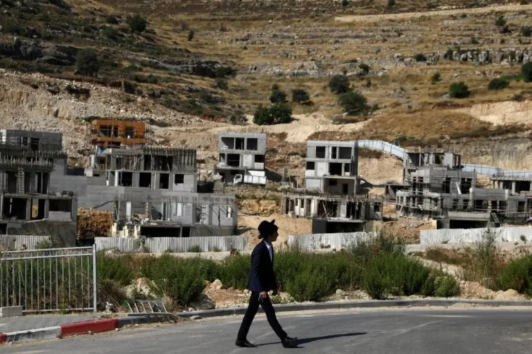
Tel Aviv, Israel – The story of the E1 area east of Jerusalem is no longer just about a project to build thousands of Israeli housing units. A new tender issued by the Israeli Ministry of Housing for the construction of 1,234 units reveals the project’s shift from the planning and approval stages to a more practical phase, alongside road and infrastructure projects and on-the-ground actions that could reshape population movement and the boundaries of geographical contiguity in the heart of the West Bank. On August 18, 2026, a tender was opened for the construction of 1,234 housing units within the larger E1 plan, which includes 3,401 previously approved units. The deadline for submitting bids is October 19, one week before the Israeli elections scheduled for October 27. And this is where the real story begins.
It’s not 1,234 apartments… it’s a piece of a larger map.
The figure that has been circulating is 1,234, but it represents only about 36% of the total units planned for E1. The area is located in a highly sensitive location between East Jerusalem and the settlement of Ma’ale Adumim, and at the heart of the geographical area connecting Ramallah, East Jerusalem, and Bethlehem. The European Union has described E1 as one of the most strategically sensitive areas of the West Bank, warning that implementing the project would sever the geographical contiguity between the northern and southern parts of the West Bank, hinder the emergence of a cohesive Palestinian urban area between Ramallah, East Jerusalem, and Bethlehem, and further integrate Ma’ale Adumim into the Israeli urban landscape. Therefore, the most important question is not: How many housing units will be built? But rather: What will these units do when placed within a network of roads, utilities, and infrastructure?
The road before the house
Previous developments reveal that the E1 project is not operating in isolation from road projects. In March 2025, the Israeli government allocated 335 million shekels for the construction of a new road designated for Palestinian traffic between al-Eizariya and al-Za’im, as part of a system that European reports indicated aims to reroute Palestinian traffic between the northern and southern West Bank. According to the European Union’s 2025 report on settlements, the road could close off approximately 3% of the West Bank to Palestinians, while simultaneously facilitating connectivity between Ma’ale Adumim, the E1 area, and Israeli urban areas. The report also warned of its impact on Palestinian communities, including Khan al-Ahmar.
This point reveals the difference between building a settlement and re-engineering an area. A road, in itself, doesn’t appear to be a housing project. But it determines who moves where, who uses which route, and how areas connect. Once the traffic network is altered, land value, population centers, and future development paths change. The equation then becomes: new roads → redistribution of traffic → segregation of areas → new infrastructure → urban sprawl → a geographical reality that is difficult to reverse.
Who gets off the map?
In May 2026, the United Nations warned of the risk of forced eviction of the Khan al-Ahmar community after Israeli Finance Minister Bezalel Smotrich instructed the Civil Administration to take steps to evacuate the community as quickly as possible. The UN Human Rights Office linked this move to the E1 plan, noting that its implementation, encompassing 3,401 housing units, would affect 18 Palestinian communities, including Khan al-Ahmar, and would reshape territorial contiguity in the area. In June, the Office of the UN Committee on the Exercise of the Inalienable Rights of the Palestinian People warned that implementing the eviction order against Khan al-Ahmar would increase the risk of the forced transfer of the residents.
Thus, another layer of the story emerges. The equation is not simply: new Israeli homes, but also: Palestinian structures at risk of eviction + new roads + redistribution of movement + settlements connected to Israeli infrastructure. This is what makes E1 a geographic project before it is a real estate project.
Israel does not need to declare annexation to change reality.
Legal annexation is a political decision that can be declared in a single day. However, changing the geography requires years of construction, roads, service networks, contracts, and investments. This is where the significance of E1 lies. The European Union has stated that implementing the project will consolidate Israeli control and undermine the possibility of a geographically contiguous Palestinian state. Its report also linked the project to government investments in infrastructure in E1 and Ma’ale Adumim. The United Nations says that the E1 plan will strengthen the connection between Ma’ale Adumim and East Jerusalem at the expense of Palestinian territorial contiguity, and that it could solidify the de facto annexation. Therefore, what is happening can be viewed as annexation through infrastructure, not necessarily through a comprehensive legal declaration.
This is an analytical reading of the course of events, not a description of an official Israeli annexation decision. Why is the tender more significant than the approval? Approval of the plan was a political and planning step. The tender, however, gives construction companies the opportunity to actually participate in the project. This is why the tender for 1,234 units acquires importance that transcends its numerical size. The Peace Now organization says that the government chose to issue a new, separate tender for a portion of the project instead of opening the previous tender for all units, setting a closing date of October 19, a week before the elections. The organization believes that the timing might allow for contracts to be signed with contractors before the elections, making it more difficult for a subsequent government to cancel the project. This is a political interpretation from an Israeli human rights organization, not an official government explanation of the timing.
But the timing of the elections on October 27, compared to the tender closing date of October 19, remains a significant chronological fact worth monitoring. The question is: Is the government trying to solidify the project on the ground before the political landscape in Israel shifts? There is, as yet, insufficient evidence to definitively say so. However, the timing opens the door to three possible interpretations:
An ideological interpretation: accelerating a project the government considers part of its vision for the future of the West Bank.
An electoral interpretation: transforming the project into an achievement that a future government would find difficult to reverse.
A negotiating interpretation: creating new facts on the ground so that any future negotiations begin from a different starting point.
The distinction here is crucial: a professional investigation doesn’t need to predetermine a hypothesis; rather, it presents the facts, allowing the reader to evaluate them.
Corporates Enter a Danger Zone: This new development also opens a less visible front: corporate economic responsibility.
In May 2026, the European Union warned companies against participating in E1 tenders or other settlement projects, citing legal and reputational risks associated with involvement in settlement construction.
This means the battle over E1 is no longer confined to governments and international organizations.
Every construction contract could raise a new series of questions:
Who will win the tender?
Who will finance the construction?
Who will provide insurance?
Who will implement the road, water, and electricity networks?
Will international companies participate, or will implementation be limited to Israeli companies?
These questions could become crucial if European warnings translate from political statements into concrete actions against participating companies.
Europe sees E1 as more than just a housing project
The European stance did not stop at objecting to the housing units. In January 2026, the European Union called on Israel to halt the E1 project, considering the project and the annexation plan a threat to the territorial integrity of the West Bank and a danger to the prospects for a two-state solution. In May, the EU warned companies against participating in the E1 tenders due to the legal and reputational risks.
Britain, for its part, announced in August 2026 its opposition to the relaunch of the E1 project, describing it as a project aimed at bisecting the West Bank. On August 20, Britain, France, Germany, Italy, the Netherlands, Norway, and Canada joined in a joint condemnation of the latest development regarding the tender. Thus, the issue has expanded from a territorial dispute into a test of Israel’s relationship with its Western allies and of the ability of European governments to move from political condemnations to economic and legal measures.
Egypt: Why does Cairo view E1 as a division of the West Bank?
The Egyptian position places E1 within a broader context than just the settlement issue. On August 5, 2016, Egyptian Foreign Minister Badr Abdel-Aty stated during a meeting of the Arab Ministerial Committee in Amman that the E1 plan aims to impose a reality that divides the West Bank into northern and southern sections, and linked the continuation of these policies to the undermining of the chances of achieving peace based on a two-state solution. This perspective reveals that Cairo views the project as part of a wider struggle over the viability of a geographically contiguous Palestinian state. Here, the importance of E1 for Egypt becomes tied to the future of the regional settlement itself. If geographical contiguity between the northern and southern West Bank becomes more difficult, and access from East Jerusalem to the rest of the West Bank is governed by a network of roads and new urban areas, the question will no longer be simply: Where will the Palestinian state be established? But rather: Will there even be a contiguous geographical area that would allow for its establishment?
The real battle is not about the number of units.
The figures say the current tender includes 1,234 units out of 3,401.
But the geography tells a different story.
There are settlements.
There are roads.
There is infrastructure.
There are commercial and industrial zones.
There are Palestinian communities facing increasingly difficult legal and humanitarian situations.
There are government investments.
There are companies that are supposed to be involved in the construction process.
When these elements come together, each individual project may seem small, but together they create something larger: an urban, economic, and security network that redefines the function of the land. This is precisely where the importance of E1 lies.
What if the map were complete?
If the 1,234 units become actual buildings, followed by the remaining planned units, and the roads, commercial areas, and infrastructure are completed, the question will no longer be about a single settlement project. It will be about a new map, one in which the connection between Jerusalem and Ma’ale Adumim becomes more entrenched, while Palestinian movement between the northern and southern West Bank becomes more dependent on alternative routes. This is why the European Union has warned that E1 could prevent the development of a contiguous Palestinian urban area between Ramallah, East Jerusalem, and Bethlehem. The United Nations warns that the project will affect 18 Palestinian communities, further fragmenting the West Bank and undermining the possibility of a contiguous Palestinian state.
The annexation may begin from the road
The story that began with a tender for the construction of 1,234 housing units reveals a broader trajectory. The project doesn’t operate in isolation. Housing units require roads. Roads redistribute traffic. Traffic reshapes land value. Infrastructure establishes a built-up presence. A built-up presence creates a reality that is difficult to reverse. Therefore, the most important question regarding E1 is not the number of apartments to be built, but whether Israel is constructing the physical infrastructure that will further fragment the map of a future Palestinian state before any new negotiations even reach the table.
While formal annexation remains a political decision requiring declaration and official procedures, altering the geographic reality can happen gradually, through roads, tenders, urban planning, service networks, and construction contracts. Here, E1 becomes more than just a settlement. It is a true test of whether geography will outpace politics in shaping the future of the conflict. If this process succeeds, the future question may no longer be: Will there be a Palestinian state? Rather, the more difficult question may become: What kind of Palestinian state can exist after roads, settlements, and infrastructure have redrawn the map?