
- The Golan Heights: The Beginning of a Strategy to Control the Highlands
- Ali Al-Taher: Why is this hill important to Israel?
- Why does the high ground provide a military advantage?
- Mount Hermon: The peak that overlooks the borders
- Gaza: How does Israel use high ground?
- The West Bank: Highlands, Roads, and Control Network
- From occupying land to controlling power
- Are the highlands creating new frontiers?
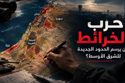
Abu Dhabi, UAE – From the Golan Heights to Mount Hermon, Ali al-Taher, the Gaza highlands, and the West Bank, an old military principle is being repeated in a new form: controlling the heights can give Israel greater surveillance, control over movement, and deterrence capabilities, without always needing to fully control the cities. Could the highlands become an alternative to occupying cities?
The Golan Heights: The Beginning of a Strategy to Control the Highlands
To understand why the Golan Heights have returned to the heart of Israeli security calculations, perhaps we should begin with the Golan Heights, which represent the clearest example of elevated geography becoming a long-term strategic asset. Israel occupied most of the Syrian Golan Heights during the June 1967 war, and since then its importance to Israel has been linked to its elevated position and its commanding view of vast areas of northern Israel and southern Syria, in addition to its status as a buffer zone of significant security value. Studies on the Golan indicate that its value was not solely based on its size, but also on the military advantage conferred by its elevation and its location in relation to movement routes and surveillance.
In the October War of 1973, Syria attempted to recapture the Golan Heights, before the fighting ended with the 1974 Disengagement Agreement, which established a buffer zone and military arrangements on both sides. However, the legal and political equation remained different from the military reality. In December 1981, Israel issued a decision to impose its laws and administration on the Golan Heights, a decision that the UN Security Council, in Resolution 497, deemed null and void and without any international legal effect.
The Golan, in this sense, not only provides a historical example of the importance of mountains, but also reveals the essence of the idea that is repeated today: controlling a high point may become more valuable than controlling a larger area if that point gives its owner the ability to see and control the surrounding area and deny the opponent its use. From the Golan, one can understand what happened later in Mount Hermon, and what is happening today in Ali al-Taher.
Ali Al-Taher: Why is this hill important to Israel?
In southern Lebanon, the picture is clearer. The Ali al-Taher heights, near Nabatieh and at an altitude of nearly 600 meters, have emerged as one of the most sensitive points of engagement between Israel and Hezbollah. The site’s importance lies not only in its mountainous location but also in the elevated position it provides, allowing for observation and control of movement routes, as well as its connection to a network of underground military sites and infrastructure. During the last war, Israel focused on controlling the surrounding heights before declaring its control over the site and incorporating it into the security zone it claims to be establishing in southern Lebanon.
Ironically, Ali Taher’s position has transcended the realm of military geography and become central to political negotiations. The site has become part of the debate surrounding Hezbollah’s disarmament and the deployment of the Lebanese army, while Israel views maintaining strategic positions as providing it with additional leverage in any settlement. Even after the ceasefire, the site remained a flashpoint directly linked to the future of security arrangements in southern Lebanon, highlighting the report’s core idea: a hill is not merely a military position when controlling it becomes a means of influencing events in its vicinity.
Why does the high ground provide a military advantage?
In military science, the value of land is not measured by its size, but by the operational advantage it provides. Military doctrine defines “commanding ground” as the area whose capture, retention, or control gives one side a clear advantage in combat. Elevation is a significant factor when it offers better visibility, wider firing ranges, or controls approach and movement routes. Therefore, capturing every hill does not necessarily constitute a strategic victory, as some heights can be bypassed. However, when a hill overlooks roads, troop concentrations, or military positions, or becomes a link between multiple axes, its value increases considerably.
This is what makes controlling high ground different from controlling cities. A city forces the attacking force to confront a complex network of buildings, people, tunnels, and streets, whereas a suitable high ground position can provide some of the capability required to monitor and influence this environment from the outside. Studies in military geography confirm that elevations and command positions on the ground can be decisive factors in the outcomes of operations, from the fronts of World War I to the battles of Gallipoli and El Alamein.
Mount Hermon: The peak that overlooks the borders
If the Golan Heights serve as the historical model, then Mount Hermon represents a more explicit example of the return of the highlands to Israeli security calculations within the Syrian context. Following the fall of Bashar al-Assad’s regime in December 2014, Israeli forces entered areas within the Golan Heights buffer zone and seized strategic positions, including sites on Mount Hermon. Israel declared its presence there to be linked to security threats, while the United Nations documented the continued Israeli presence in the buffer zone and adjacent locations.
Mount Hermon’s importance lies in its geography and location; it dominates a vast area of the border region, with its highest points situated at considerable heights compared to the surrounding areas. The United Nations describes the area of operations of the United Nations Disengagement Observer Force (UNDOF) as a mountainous region dominated by Mount Hermon to the north. Thus, the connection between the Golan Heights, Mount Hermon, and Ali Taher becomes even clearer: the greater the ability of an elevated position to monitor the surrounding area, control movement, and prevent the enemy from using the land, the greater its value, even if its area is limited.
Gaza: How does Israel use high ground?
But does Israel really need mountains to apply this equation? The Gaza situation provides the answer: not necessarily. Gaza is not a mountainous area, but Israeli military operations have shown an interest in high ground, whether through limited natural hills and elevations, buildings and facilities, or barricades and military sites that provide a wider view of the surrounding area.
In areas like Beit Hanoun and Shuja’iyya, military movements were linked to the establishment of observation posts and vantage points that granted troops a better view of the surrounding areas and control over movement patterns. Reports indicated Israeli positions in northern Gaza that provided a strategic view towards Beit Hanoun, Beit Lahia, Jabalia, and Gaza City. In this context, the term “high ground” becomes broader than a mountain itself. It could refer to a tall building, a fortified position, an earthen berm, or a piece of land elevated above its surroundings. What matters is not the shape of the elevation, but what can be seen and controlled from it.
The West Bank: Highlands, Roads, and Control Network
In the West Bank, the equation appears more complex, because the highlands do not operate in isolation, but rather within a network of roads, settlements, barriers, and observation points. Mountainous areas extend along the heart of the West Bank, intersected by major roads, most notably Route 60, while control points, roads, and high-altitude locations play a role in reshaping the movement of Palestinians between cities and villages.
According to the United Nations Office for the Coordination of Humanitarian Affairs (OCHA), the number of movement barriers in the West Bank reached 925 as of December 2025. These include checkpoints, road gates, linear closures, earth mounds, and barriers, directly impacting the movement of millions of Palestinians. OCHA noted that hundreds of these barriers impede access between Palestinian towns and villages and main roads. Here, the objective is not necessarily to control a “city from above,” but rather to construct a geographical network that enables movement control by controlling the junctions, roads, and locations through which movement passes. This expands the concept of “high ground” from a “mountaintop” to a system of territorial control.
From occupying land to controlling power
Taking these four cases together, a different picture emerges from the traditional concept of occupation. The Golan Heights presents a long-term model for controlling high ground with strategic security value. Mount Hermon illustrates the importance of a summit in monitoring the border area. Ali Taher demonstrates how a single hill can become a bargaining chip in disarmament negotiations. Gaza and the West Bank show how elevated positions, commanding points, and strategic roads can be used to alter the operational environment without the need to occupy every city and every street.
Therefore, perhaps the most accurate statement is that Israel does not absolutely replace cities with high ground, but rather seeks in some cases to control capability rather than control of space. Control of high ground may mean monitoring a road, denying the enemy a launching position, securing a border area, providing additional depth, and putting pressure on the movement of forces or the population. This explains why a small area can become more valuable than a large area that does not give its owner a similar advantage.
Are the highlands creating new frontiers?
The landscape stretching from the Golan Heights to Mount Hermon, Ali al-Taher, Gaza, and the West Bank suggests a shift in the way Israeli military maps are read. The question is no longer just: What cities or areas does Israel control? Rather, the more precise question has become: What points does it control, and what can it do from above them? If controlling a city means controlling its area, population, and infrastructure, then controlling the high ground could mean controlling what surrounds the city: its roads, entrances, field of vision, military positions, and the enemy’s ability to move within it.
Herein lies the paradox: power may not need to redraw borders on a map to alter geographical reality. Sometimes, it suffices to seize the points that make the entire map function differently. From the Golan Heights to Mount Hermon, from Ali Taher to the Gaza and West Bank highlands, geography seems to be re-emerging as a weapon in its own right. High ground is not an absolute substitute for cities, but it can be a substitute for total control when the goal is to control power, not the population. Ultimately, a single hill can be more important than an entire city if the summit grants whoever controls it the ability to see and influence their surroundings.