- The decision to leave has been made, but the fate of the “map” has not been publicly decided.
- The Blue Line is not a border… but it is the most dangerous line in the region.
- The surprise: UNIFIL is not just a force on the ground
- 272 marks on the ground… and almost half the line is unmarked
- When the coordinates become more important than the soldier
- Who owns “digital truth”?
- And more importantly: who will inherit the record of violations?
- A new war on the “map”?
- The last war left a “broken memory” on the ground.
- Not all “maps of Lebanon” belong to UNIFIL.
- The potential “heir” is not necessarily a military force.
- From soldier to algorithm
- What happens the day after UNIFIL leaves?
- What do the documents reveal… and what do they not reveal?
- Why does this matter to Lebanon, Israel, and the world?
Abu Dhabi, UAE – An investigation traces the fate of the “geographical memory” of the Blue Line before UNIFIL’s withdrawal from southern Lebanon. Who possesses the coordinates that pinpoint the location of violations? And who maintains the record of what transpired on the ground? In southern Lebanon, the Blue Line may appear to be merely a line drawn on maps and blue markers scattered across hills and valleys. But behind this line lies a far more complex system: geographical coordinates, historical maps, field measurements, photographs and surveys, border markers, patrol reports, and records of incidents and violations. This system allows the United Nations to determine whether a point lies north or south of the line, whether a military object crossed the line or remained behind it, and whether a particular incident constitutes a violation of Resolution 1701.
As the mandate of the United Nations Interim Force in Lebanon (UNIFIL) draws to a close, a question arises that has not received the same attention as the military withdrawal: What will happen to the data that UNIFIL has compiled over the decades? The question is not merely technical. Whoever possesses the map, the coordinates, and the verification record holds a significant portion of the power to determine the official narrative of what is happening on the ground.
The decision to leave has been made, but the fate of the “map” has not been publicly decided.
On August 28, 2025, the Security Council adopted Resolution 2790, extending UNIFIL’s mandate for the last time until December 31, 2026, with an orderly and safe withdrawal to begin that date and continue for one year. However, the resolution was not the end of the story. In June 2026, UN Secretary-General António Guterres presented the Security Council with options for implementing Resolution 1701 after UNIFIL’s withdrawal, at a time when the future of the international presence in southern Lebanon was still under negotiation. By August 2026, there was no clear, final agreement on the structure that would assume all of UNIFIL’s functions. Recent reports have discussed several options, including a smaller international presence or multilateral arrangements, while European proposals for a civil-military presence after UNIFIL’s mission ends have also been put forward. Herein lies the gap: whoever inherits the territory will undoubtedly need to monitor it, but who will inherit the data that makes monitoring verifiable?
The Blue Line is not a border… but it is the most dangerous line in the region.
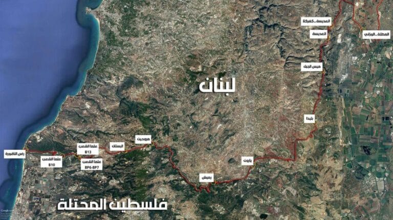
The first paradox is that the “Blue Line” is not an internationally agreed-upon border between Lebanon and Israel. The United Nations designated it in 2000 as a withdrawal line to confirm the withdrawal of Israeli forces from Lebanese territory, not as a final border demarcation. The line is approximately 120 kilometers long. This point is crucial for understanding the investigation. If the Blue Line is not a final international border, then the value of the UN map becomes even greater, because it is not merely a geographical document, but a tool used for de-escalation and identifying violations.
UNIFIL states that the demarcation line was based on historical maps and documents that were not always clear when projected onto the actual terrain. Crucially, in 2000, the UN sent the parties a map of the line at a scale of 1:50,000, along with a list of 198 selected coordinates to define its entire course. According to UNIFIL, these two documents remained the official sources for the line, although the parties differed on some details. In other words, the map is not a picture that can be easily replaced. It is a political, legal, and practical reference.
The surprise: UNIFIL is not just a force on the ground
Research into UNIFIL’s official documents reveals that one of the most sensitive roles along the Blue Line is not played by the soldier carrying the weapon, but rather by the team operating the measuring equipment and digital maps. UNIFIL utilizes Geographic Information Systems (GIS) teams to pinpoint the exact locations of the Blue Line markers. In the process of installing a marker, Lebanese teams measure the point, which UNIFIL then verifies using mapping techniques. Verification is also conducted on the Israeli side before the marker is installed. In a previous operation, UNIFIL described the mechanism as a process of measurement and verification between the parties, ensuring that the marker is only erected after the coordinates have been verified. Thus, the “blue barrel” that residents see becomes merely the visible culmination of a long series of data and measurements. The barrel is not the map itself; it is a physical marker built upon the map.
272 marks on the ground… and almost half the line is unmarked
Official data paints a more complex picture. UNIFIL states that the Blue Line stretches for 120 kilometers, but visible markers cover only about half its length. Before the recent escalation, there were 272 markers along the line, before fighting damaged or destroyed dozens of them. In October 2025, UNIFIL announced that an assessment showed 24 markers were damaged and 33 destroyed during the conflict, and that its GIS team had pinpointed the exact locations of the markers being repaired. A UN report issued in March 2026 indicated that UNIFIL had repaired 18 of the 62 damaged or destroyed markers since October 8. Herein lies a crucial paradox: while a physical marker can be destroyed, it is the digital coordinates that allow for its reconstruction. Therefore, the question of the fate of the data becomes more important than the question of the fate of the blue barrels themselves.
When the coordinates become more important than the soldier
In one incident documented in a report by the Secretary-General, tension arose after an object was placed near the Blue Line. The question wasn’t merely political: where was the object located? UNIFIL used a Geographic Information System (GIS) to take measurements. The measurements showed the object was located a few meters south of the line, which helped initiate dialogue between the parties and end the confrontation. This incident reveals a function not usually seen in patrol photos: geographic data can instantly become a de-escalation tool. It identifies: where the line is located; where the marker is located; where the object or activity occurred; whether a crossing took place; and whether the disputed location is north or south of the line. Therefore, the loss of the data system or the lack of clarity regarding who will manage it after UNIFIL may not simply be an archival problem. It could become a security issue.
Who owns “digital truth”?
Here the investigation arrives at the most sensitive question. UNIFIL official documents describe the United Nations as the custodian of the Blue Line, noting that both parties have accepted UNIFIL as the authority regarding the line and related violations. However, this status is tied to the existing UN framework. As the mandate nears its end, a new question arises: Will this function remain with the UN, or will it be transferred to: a new international force? A smaller UN mechanism? The Lebanese army? A multinational entity? A joint Lebanese-Israeli mechanism? Or multiple entities, with one party retaining the maps and another monitoring them? The public sources we have reviewed so far do not offer a detailed, published plan that clearly identifies who will ultimately hold the geographical authority for the Blue Line after UNIFIL’s mandate expires. This is one of the investigation’s most significant findings: the world is negotiating who will replace UNIFIL, but the issue of “who will inherit the geographic database” has not yet emerged as a publicly declared political issue.
And more importantly: who will inherit the record of violations?
UNIFIL does more than just draw maps. Its mandate includes monitoring the situation and reporting violations of Resolution 1701 to the Security Council. UNIFIL affirms that crossing the Blue Line by land or air constitutes a violation of the resolution, and that violations observed by its soldiers are reported to the Security Council. This means there are three interconnected layers: location → evidence → report. The location is determined by coordinates, and the evidence could be a measurement, observation, photograph, or patrol report. The result then becomes an official report. If the entity responsible for the first layer changes, the method of producing the second and third layers may also change. This is the aspect that is not featured in the political headlines about “UNIFIL’s departure.”
A new war on the “map”?
The Blue Line itself is not fixed in a political sense. The UN states that there are areas where the parties have reservations, and some points have not been agreed upon for demarcation on the ground. UNIFIL documents indicate that Lebanon expressed reservations in 13 areas, while Israel did not specify the number and locations of its reservations to the UN in the same way in the document explaining the line’s mechanism. Furthermore, the process of marking the line itself requires agreement between the parties on the point before the marker is erected. Thus, the digital map does not eliminate politics; rather, it operates within an incomplete political space. This makes the question even more critical: if the parties disagree on a point in the future, who will have the reference version of the historical coordinates and measurements that prove how the point was defined before UNIFIL’s departure?
The last war left a “broken memory” on the ground.
The destruction of the Blue Line markers is not merely physical damage. It is a practical test of the value of geographic records. In 2025, UNIFIL stated that its teams used aerial and ground reconnaissance to assess the damage, while a GIS team determined the precise locations of the reconstructed markers. In other words, the reconstruction of the markers did not start from scratch. There was a pre-existing geographic record that allowed for re-locating the sites. This leads to an important conclusion: the more a marker is destroyed on the ground, the more valuable the data behind it becomes. The marker is reconstructable. However, the loss of the measurement chain and historical documentation can make reconstructing “spatial reality” much more complex.
Not all “maps of Lebanon” belong to UNIFIL.
Here, a common misconception in reporting on the issue must be avoided. Referring to the “UNIFIL map” does not imply that the organization possesses all geographical maps of Lebanon. There is a difference between general maps of the Lebanese state and the operational database linked to the Blue Line and the monitoring system of Resolution 1701. The latter includes operational layers related to monitoring, deployment, markers, coordinates, and reporting. Furthermore, the Lebanese Army itself has geographical teams working with UNIFIL to measure and verify points along the line. Therefore, the real question is not, “Does UNIFIL possess a map of Lebanon?” but rather, “Who possesses the reference version of the data that defines the Blue Line and links coordinates to incidents and reports?”
The potential “heir” is not necessarily a military force.
Current political developments confirm that the post-UNIFIL phase will not necessarily be a mere replica of the current force. In August 2026, Reuters revealed that Lebanon and Israel had reached a shortlist of countries that could contribute troops to a mechanism to verify Hezbollah’s disarmament, within arrangements linked to a US-brokered agreement, while also exploring the possibility of placing the force under a UN framework or another international mechanism. Simultaneously, European reports spoke of a feasibility study for a civil-military mission that could begin in 2027. This suggests that the likely successor could be a multilateral system. Herein lies a new problem: if monitoring is distributed among several actors, who can guarantee that all parties use the same coordinates and geographic reference points?
From soldier to algorithm
The future may make the question even more complex. Modern border surveillance doesn’t rely solely on soldiers. It utilizes satellite imagery, drones, GIS systems, time-based databases, aerial photographs, digital maps, GPS devices, geographic analysis systems, and potentially, in the future, artificial intelligence tools to analyze changes on the ground. However, technology alone cannot resolve the question of legitimacy. If a satellite captures an image of a vehicle near a border, the image requires precise geographic reference. If an AI system identifies a change in location, the analysis needs a reliable database for comparison. Therefore, while AI can read a map, it cannot single-handedly determine which map constitutes the legitimate political reference.
What happens the day after UNIFIL leaves?
The scenario can be easily envisioned: a new international patrol detects activity near the Blue Line – a coordinate is displayed – the location is identified, and the question arises: is the location inside or outside the line? If there is a unified reference system, the answer is clear, both technically and politically. However, if there are different maps, asynchronous databases, or multiple entities using different references, the dispute can move from the ground to the screen, from the screen to the operations room, and from the operations room to the Security Council. Here, the dispute over a “point” becomes a dispute over the narrative.
What do the documents reveal… and what do they not reveal?
What we know: The Blue Line is about 120 kilometers long – the UN designated it in 2000 as a withdrawal line, not an international border – there is a UN map and a list of reference coordinates for the line – UNIFIL uses GIS to identify and verify points on the line – the line is visible with markers for only about half its length – dozens of markers were destroyed or damaged during the recent conflict, and some have been rebuilt based on GIS determinations – UNIFIL monitors and reports to the Security Council on violations of Resolution 1701 – UNIFIL’s current mandate ends on December 31, 2026, with a planned withdrawal during 2027 – the UN is already exploring options for the next phase.
What we do not know publicly so far is who will become the reference authority for the geographic data of the Blue Line after the end of UNIFIL’s mandate? And will the following be transferred: the complete coordinate database? – digital maps? – measurement archives? – marker records? – historical incident data? – operational map layers? – photo and reconnaissance archives? – records of violations linked to coordinates? – and to whom? – And will the transfer be complete legally, technically and institutionally, or will parts of the data remain within the UN archives? These questions are the gap that the public documents reviewed by the investigation have not resolved.
Why does this matter to Lebanon, Israel, and the world?
Because southern Lebanon doesn’t just need a force to separate two sides. It needs a shared record of the truth. The presence of an international soldier at a certain point can end with their departure. But recording coordinates, preserving measurements, documenting incidents, and establishing images and dates can last for decades. Therefore, UNIFIL’s true legacy may not be the thousands of soldiers leaving the south. It may be the tens of thousands of data points that go unseen.
After nearly half a century of UN presence in southern Lebanon, UNIFIL is preparing to begin its withdrawal. But the question preceding the departure of the last patrol should not be simply: Who will protect the Blue Line? Rather, who will have the authority to verify where the Blue Line was and what transpired along it? The line that appears on a map as a single blue line is, in reality, a network of coordinates, measurements, documents, agreements, and reports. As UNIFIL’s mandate nears its end, the most dangerous potential vacuum may not be a military one. It could be a vacuum in the “memory of the place.” If the international force withdraws without a declared and transparent mechanism to ensure the continuity of geographical reference and documentation, the map may not disappear. But the more critical question will then arise: Which map will the world accept?